
Introduction
The rise of drones in real estate
The rise of drones in real estate has revolutionized the way properties are captured and showcased. With the ability to capture stunning aerial views and provide a unique perspective, drones have become an essential tool for real estate professionals. These unmanned aerial vehicles offer a cost-effective and efficient solution for capturing high-quality images and videos of properties, allowing potential buyers to get a comprehensive view of the property’s layout and surroundings. Drones also enable real estate agents to highlight the key features of a property, such as its size, location, and amenities, in a visually appealing and captivating way. Additionally, drones can be used to create immersive virtual tours, giving potential buyers the opportunity to explore a property from the comfort of their own homes. As the demand for visually engaging and informative property listings continues to grow, the use of drones in real estate is expected to become even more prevalent in the future, transforming the way properties are marketed and sold.
Benefits of using drones in real estate
Drones have revolutionized the real estate industry by providing a new perspective on property listings. The benefits of using drones in real estate are numerous. Firstly, drones allow for stunning aerial photography and videography, capturing properties from a unique and captivating angle. This not only attracts potential buyers but also helps sellers showcase their properties in a more visually appealing way. Additionally, drones can quickly and efficiently survey large areas of land, providing valuable data for developers and investors. This saves time and resources compared to traditional methods of surveying. Furthermore, drones can be used to create 3D models of properties, allowing potential buyers to virtually explore a property before physically visiting it. This enhances the decision-making process for both buyers and sellers. Overall, the use of drones in real estate has proven to be a game-changer, offering numerous benefits that enhance the buying and selling experience for all parties involved.
Overview of the article
In the article titled ‘Drone Services and Real Estate: Capturing Properties from a New Height’, the author provides an insightful overview of the role of drones in the real estate industry. The article explores how drones are revolutionizing the way properties are captured and showcased, offering a unique perspective from a new height. With the ability to capture stunning aerial imagery and videos, drones are enabling real estate professionals to provide potential buyers with a comprehensive view of properties, highlighting their features and surrounding areas. This paragraph sets the stage for the article, highlighting the importance of drone services in the real estate sector and the impact they have on property marketing and sales.
How drones are transforming the real estate industry

Aerial photography and videography
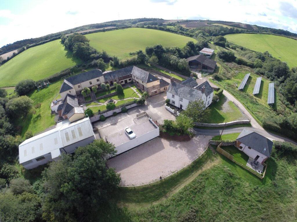
Aerial photography and videography have revolutionized the way real estate properties are showcased and marketed. With the advent of drone technology, capturing stunning aerial shots of properties has become more accessible and cost-effective. Drones equipped with high-resolution cameras can capture detailed images and videos from unique angles, providing potential buyers with a comprehensive view of the property’s features and surroundings. This innovative approach not only enhances the visual appeal of real estate listings but also allows potential buyers to get a better sense of the property’s layout and location. By incorporating aerial photography and videography into their marketing strategies, real estate professionals can effectively highlight the unique selling points of a property and attract a wider audience. Whether it’s showcasing the expansive grounds of a luxury estate or capturing the breathtaking views from a high-rise condominium, aerial photography and videography offer a compelling way to capture the essence of a property from a new height.
Virtual tours and 360-degree views
Virtual tours and 360-degree views have become an essential tool for the real estate industry, revolutionizing the way properties are showcased to potential buyers. With the advent of drone services, real estate agents can now provide a unique and immersive experience to their clients. By capturing stunning aerial footage and creating virtual tours, drones allow prospective buyers to explore properties from a whole new perspective. This technology not only gives a comprehensive view of the property but also highlights its key features, such as the surrounding landscape, neighborhood amenities, and architectural details. With virtual tours and 360-degree views, potential buyers can get a realistic sense of the property’s layout and design, helping them make informed decisions without physically visiting the site. The use of drones in real estate has opened up new possibilities for marketing properties and attracting buyers, making it an invaluable tool in today’s competitive market.
Improved property inspections
Improved property inspections have become a game-changer in the real estate industry, thanks to the advent of drone services. Drones provide a unique perspective that allows for a comprehensive view of properties from a new height. This technology enables real estate professionals to capture stunning aerial images and videos, showcasing the entire property and its surroundings in a way that was previously impossible. By utilizing drone services, property inspections are now more efficient, accurate, and cost-effective. The ability to identify potential issues, assess property conditions, and highlight key features has revolutionized the way real estate agents and buyers evaluate properties. With drone services, real estate professionals can offer their clients an immersive experience, giving them a true sense of the property’s scale, location, and potential. As the demand for high-quality visual content continues to grow, drone services have become an essential tool for real estate professionals looking to stay competitive in the market.
Legal considerations for using drones in real estate

FAA regulations and licensing
FAA regulations and licensing play a crucial role in the integration of drone services in the real estate industry. As the popularity of using drones for capturing aerial footage of properties continues to grow, it is important to ensure compliance with the regulations set forth by the Federal Aviation Administration (FAA). These regulations are in place to ensure the safety and privacy of individuals and property, as well as to prevent any potential hazards that may arise from the use of drones. In order to legally operate drones for commercial purposes, individuals and businesses must obtain the necessary licenses and certifications from the FAA. This includes passing a knowledge test and adhering to specific operational guidelines. By following these regulations and obtaining the required licensing, drone operators can provide real estate professionals with a valuable tool for showcasing properties from a new and captivating perspective.
Privacy concerns and data protection
Privacy concerns and data protection are important considerations when it comes to the use of drone services in the real estate industry. With drones being able to capture high-resolution images and videos of properties from a new height, there is a potential risk of invading people’s privacy. Homeowners and tenants may feel uncomfortable knowing that their personal spaces are being monitored from above. Additionally, there is a concern about the collection and storage of data gathered by drones. It is crucial for real estate professionals and drone operators to ensure that they comply with privacy laws and regulations to protect the privacy of individuals. Implementing measures such as obtaining consent, blurring faces and license plates, and securely storing data can help address these privacy concerns and ensure data protection in the drone services and real estate industry.
Insurance requirements
When it comes to using drones in the real estate industry, one important aspect that cannot be overlooked is insurance requirements. As drones become more prevalent in capturing properties from a new height, it is crucial for real estate professionals to understand the insurance coverage needed to protect themselves and their clients. Insurance requirements for drone services in real estate typically include liability coverage, property damage coverage, and personal injury coverage. This ensures that in the event of any accidents or mishaps during drone operations, both the drone operator and the property owner are financially protected. Additionally, some insurance policies may also include coverage for privacy violations and data breaches, which are important considerations in the age of technology. By adhering to insurance requirements, real estate professionals can confidently incorporate drone services into their business strategies, knowing that they are adequately protected and can provide a safe and secure experience for their clients.
Choosing the right drone for real estate photography
Camera specifications and image quality
Camera specifications and image quality play a crucial role in the success of drone services in the real estate industry. With advancements in technology, drones are now equipped with high-resolution cameras that can capture stunning aerial images and videos of properties. These cameras have the ability to capture intricate details and provide a comprehensive view of the property, showcasing it from a new height. The image quality is of utmost importance as it determines the clarity and sharpness of the visuals, allowing potential buyers to get a realistic and immersive experience of the property. The camera specifications, such as megapixels, lens quality, and sensor size, directly impact the image quality and overall effectiveness of the drone services. Real estate professionals can leverage these advanced camera capabilities to showcase properties in a visually appealing and impactful way, attracting more potential buyers and increasing the chances of a successful sale.
Flight time and range
Flight time and range are crucial factors to consider when using drone services for real estate. The longer the flight time, the more properties can be captured in a single session, saving time and resources. Additionally, a greater range allows for the exploration of larger properties, ensuring that every corner is captured from a new height. By utilizing drones with extended flight time and range capabilities, real estate professionals can efficiently and effectively capture stunning aerial images and videos of properties, showcasing them in a unique and compelling way.
Portability and ease of use
Portability and ease of use are two key advantages of using drone services in the real estate industry. Drones are lightweight and compact, making them highly portable and easy to transport to various locations. This allows real estate professionals to quickly and efficiently capture aerial footage and images of properties from different angles and heights. Additionally, drones are user-friendly and require minimal training to operate. With their intuitive controls and automated features, even beginners can easily navigate and control the drone to capture stunning visuals. The portability and ease of use of drone services make them a valuable tool for real estate professionals, enabling them to showcase properties in a unique and captivating way.
Tips for capturing stunning aerial shots of properties

Planning the flight path and shot composition
Planning the flight path and shot composition is a crucial step in utilizing drone services for capturing properties from a new height. By carefully mapping out the flight path, drone operators can ensure that every corner of the property is covered, providing a comprehensive view for potential buyers. Additionally, considering shot composition allows for the creation of visually appealing and informative images and videos. This involves determining the best angles, distances, and heights to capture the property’s unique features and highlights. With proper planning, drone services can truly enhance the real estate industry by providing a fresh perspective and captivating visuals.
Optimizing camera settings for different lighting conditions
When it comes to capturing real estate properties using drones, optimizing camera settings for different lighting conditions is crucial. The right camera settings can make a significant difference in the quality and clarity of the aerial photographs and videos. In bright daylight, adjusting the exposure settings to prevent overexposure and maintaining proper white balance is essential. On the other hand, in low-light conditions, increasing the ISO sensitivity and using longer shutter speeds can help capture well-lit images. By understanding and adjusting the camera settings based on the lighting conditions, real estate professionals can ensure that the drone-captured visuals showcase the properties in the best possible way.
Editing and enhancing drone photos
Editing and enhancing drone photos is an essential step in the process of capturing properties from a new height. With the advancements in technology, drones have become an integral tool for real estate professionals to showcase properties in a unique and captivating way. However, raw drone photos often require editing to bring out the best features of a property. This can involve adjusting the exposure, color correction, cropping, and removing any unwanted elements from the image. By carefully editing and enhancing drone photos, real estate professionals can create stunning visuals that highlight the property’s key selling points and attract potential buyers. The use of professional editing software and techniques ensures that the final images are of the highest quality, providing a true representation of the property’s beauty and appeal. Whether it’s enhancing the vibrant colors of a sunset shot or removing any distractions from the background, editing drone photos allows real estate professionals to present properties in the best possible light, ultimately increasing their chances of a successful sale.
Future trends and advancements in drone technology for real estate

Artificial intelligence and automated flight
Artificial intelligence and automated flight have revolutionized the drone services industry, particularly in the realm of real estate. With the integration of AI technology, drones are now capable of capturing properties from a new height, providing real estate professionals with a unique and comprehensive perspective. Automated flight allows for precise and efficient maneuvering, ensuring that every angle and detail of a property is captured with accuracy. This not only saves time and effort for real estate agents but also enhances the overall experience for potential buyers, who can now explore properties virtually and in great detail. The combination of AI and automated flight has truly transformed the way real estate is showcased and marketed, bringing a new level of innovation and efficiency to the industry.
Virtual reality integration
Virtual reality integration is revolutionizing the real estate industry by providing a new and immersive way for potential buyers to experience properties. By combining the power of drones and virtual reality technology, real estate professionals can showcase properties from a whole new perspective. With virtual reality headsets, potential buyers can take virtual tours of properties, giving them a sense of actually being inside the space. This technology allows for a more accurate representation of the property, helping buyers make informed decisions without the need for physical visits. Virtual reality integration is not only changing the way properties are marketed, but also enhancing the overall buying experience for customers.
Enhanced data analytics for property evaluation
With the advent of drone services in the real estate industry, property evaluation has taken a giant leap forward. One of the key advancements in this field is the use of enhanced data analytics. By utilizing drones to capture high-resolution aerial images and videos, real estate professionals can gather a wealth of data about a property. This data can then be analyzed using sophisticated algorithms and machine learning techniques to extract valuable insights. From identifying potential risks and opportunities to assessing the condition and value of a property, enhanced data analytics has revolutionized the way properties are evaluated. Real estate agents and investors can now make more informed decisions based on accurate and up-to-date information, leading to better investment opportunities and improved profitability. The combination of drone services and enhanced data analytics has truly transformed the real estate industry, allowing for a more efficient and comprehensive property evaluation process.


