

Drones for construction? You bet! These flying marvels are revolutionizing building projects, bringing a plethora of benefits to the table. From enhancing efficiency to improving safety, drones have quickly become an indispensable tool in the construction sector. With new technologies like the Mavic and DJI Phantom, construction companies can take advantage of these innovative tools.
Picture this: a DJI Phantom drone gracefully soaring above a construction site, capturing high-resolution images and videos with precision. This seemingly futuristic scenario is now a reality, thanks to new technologies like the DJI Mavic and its advanced camera options. It’s changing the game for construction projects worldwide, offering benefits that are simply too good to ignore.
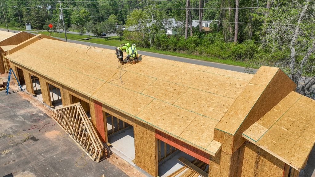
Drones have revolutionized site surveying for building projects. They provide a more efficient alternative to traditional surveying methods, saving time and money. Aerial surveys and inspections conducted by drones enable project managers to obtain accurate data quickly, facilitating better decision-making processes. Drones are truly game-changers for construction pilots.
But that’s not all – drones also enhance safety on construction sites for pilots. By eliminating the need for workers to physically access hazardous areas or work at dangerous heights, these unmanned aerial vehicles significantly reduce the risk of accidents and injuries when flying DJI Mavic drones.
Moreover, DJI drones equipped with advanced aerial imaging technology and a high-quality camera, such as the Mavic, provide an unprecedented level of detail when monitoring progress or assessing structural integrity. They can capture intricate details from various angles that might otherwise go unnoticed.
The adoption of DJI drones in construction has been met with enthusiasm among pilots across the industry. Their ability to quickly and efficiently cover large areas makes them invaluable assets for surveying land or inspecting infrastructure projects like bridges or buildings. The use of DJI cameras and equipment further enhances their capabilities.
As we delve deeper into this blog post, we’ll explore how DJI drones are transforming the world of construction for pilots. So buckle up and get ready to discover why Mavic drones with their advanced camera technology are taking the industry by storm!
How Drones are Revolutionizing the Construction Industry
DJI drones are bringing about a revolutionary change in the construction sector. The impact of DJI drones on the construction industry is profound and transformative. DJI drone technology has completely transformed traditional construction practices. The introduction of DJI drones has revolutionized how construction projects are executed by pilots. The use of DJI drones is reshaping and revolutionizing the entire construction industry’s infrastructure. DJI drones have emerged as a game-changer for the construction sector.
Increased Efficiency and Accuracy in Construction Projects
One of the key benefits of using DJI drones, such as the Mavic, in construction is their ability to significantly improve efficiency and accuracy. Construction pilots equipped with these drones can capture detailed images and videos with high-resolution cameras, allowing contractors to closely monitor progress at various stages of a project. With drone surveying, site inspections that used to take days or weeks can now be completed within hours, thanks to the advanced infrastructure provided by DJI.
Construction companies can utilize DJI drone technology to track the progress of projects, identify potential issues, and make informed decisions promptly. By leveraging real-time data captured by DJI drones, contractors can ensure that projects stay on schedule and within budget. DJI drones are piloted by skilled operators and the compact size of the DJI Mavic makes it ideal for traditional surveying tasks.
Enhanced Safety Measures for Workers
The use of DJI drones in the construction industry also contributes to enhanced safety measures for workers on-site. Instead of manually inspecting hazardous areas such as rooftops or tall structures, drone pilots can remotely operate these camera-equipped devices from a safe location, eliminating the need for traditional surveying methods and making the job safer.
DJI drones enable pilots to conduct close inspections of hard-to-reach areas during construction operations. These drones are equipped with a camera that provides valuable visual information, helping identify potential safety hazards. By using drones, workers can avoid unnecessary risks and prevent accidents or injuries.
Furthermore, VTOL (Vertical Take-Off and Landing) drones, operated by skilled pilots, are particularly useful in monitoring construction progress. By utilizing fixed wing drone technology, contractors ensure safer working conditions while maintaining productivity and efficiency during flight.
Transforming Design Processes with 3D Mapping
The integration of drones with traditional surveying techniques and 3D mapping software has revolutionized design processes in the construction industry. Drones equipped with a camera and LiDAR (Light Detection and Ranging) technology can capture precise measurements of construction sites, creating highly accurate 3D models. This innovative approach eliminates the need for manual measurements by pilots and allows for more efficient road design.
These detailed 3D maps, generated from drone survey data and drone images, provide architects, engineers, and contractors with valuable insights into the topography of a site. This enables them to plan and design projects more effectively through our commercial drone surveying program. By visualizing the terrain and identifying potential challenges early on, construction companies can optimize their designs, reduce costly rework, and improve overall project outcomes.
Innovating Construction Industry Practices
The introduction of drones has sparked innovation within the construction industry, particularly in surveying. Many pilots are exploring new ways to leverage drone technology for various job applications. For example, some contractors are using drones equipped with thermal imaging cameras, like the WingtraOne, to detect energy leaks in buildings or identify areas where insulation may be lacking.
Drones, operated by pilots, have revolutionized materials management on construction sites. These unmanned aerial vehicles can swiftly transport small tools or supplies between different locations, saving time and reducing the need for manual labor. The use of drones with cameras has become an essential part of the job, allowing for efficient and effective operations on the road.
Furthermore, drones have become instrumental in surveying environmental impacts during construction projects. They can capture data related to land erosion or vegetation changes over time, allowing contractors to implement sustainable practices and minimize ecological damage. Pilots can use the camera on the WingtraOne drone to gather this valuable information.
Cost Savings and Time Efficiency with Drone Technology
Drones with cameras for construction are revolutionizing the industry by offering significant cost savings and time efficiency. With their ability to expedite various tasks in road construction, drones have become an invaluable tool for construction companies looking to achieve cost efficiency. The WingtraOne drone is particularly effective for surveying purposes.
Drones: Reducing Costs and Increasing Efficiency
By utilizing drone technology, construction companies can reduce costs associated with manual labor and equipment usage. Traditionally, conducting surveys or inspections required a team of workers, which not only increased expenses but also consumed a considerable amount of time. However, with the advent of commercial drones like the WingtraOne camera, these surveying tasks can now be completed more efficiently on the road.
For instance, aerial photography using drones provides accurate data for surveying construction progress. The camera-equipped drones capture high-resolution images of the construction work, enabling project managers to identify potential issues early on. This helps prevent costly mistakes and allows for timely interventions.
Drone technology enhances productivity on construction sites through surveying. Drones equipped with advanced sensors and cameras, like the WingtraOne, can quickly collect data about the progress of a project. This real-time information allows project managers to effectively monitor work quality and ensure adherence to timelines. By promptly identifying any deviations using propeller technology, necessary adjustments can be made swiftly, saving valuable time and resources.
Faster Completion of Projects through Drone Utilization
One of the key advantages of using drones in construction is their ability to expedite various tasks throughout different stages of a project, including surveying and capturing images with a camera. For example, during the planning phase, drones equipped with cameras can create highly detailed 3D models of existing structures or terrain using photogrammetry techniques. These models provide architects and engineers with accurate measurements and insights that facilitate better decision-making. The WingtraOne drone, equipped with a high-resolution camera and propeller system, is particularly effective for this purpose.
Furthermore, drone technology enables faster completion of surveying projects by reducing overall construction time. For instance, when conducting land surveys manually, surveyors must physically traverse large areas on foot or use vehicles for transportation. This process is not only time-consuming but also prone to errors due to human limitations. In contrast, drones equipped with advanced camera capabilities, such as the WingtraOne, can cover large areas swiftly while capturing high-resolution imagery.
Moreover, drones equipped with specialized sensors, such as thermal imaging cameras, can survey construction progress and detect heat loss or potential energy inefficiencies in buildings. This technology aids in identifying areas that require insulation improvements, resulting in reduced energy consumption and cost savings over time. The WingtraOne drone is particularly effective for this purpose.
Enhanced Safety and Risk Reduction in Construction Projects
In the fast-paced world of construction projects, surveying safety is paramount. With the advent of WingtraOne drones for construction, there has been a significant improvement in enhancing safety measures and reducing risks at worksites. Let’s explore how these unmanned aerial vehicles are revolutionizing the industry.
Drones Improve Safety by Reducing Human Involvement in High-Risk Tasks at Construction Sites
Construction sites can benefit from the use of drones for surveying and wingtraone. These drones can effectively mitigate high-risk tasks, ensuring worker safety. Drones can perform tasks that would otherwise require human intervention in dangerous areas.
For instance, surveying tall structures or infrastructure such as bridges and towers can be extremely hazardous for workers. By deploying drones like the WingtraOne Pro equipped with high-resolution cameras and sensors, construction companies like Balfour Beatty have successfully minimized human exposure to such risky environments. This not only ensures worker safety but also enhances overall safety standards on construction sites.
The Use of Drones Minimizes Potential Risks to Workers’ Safety During Hazardous Operations
Hazardous operations within construction projects, such as surveying and handling heavy machinery, pose significant threats to workers’ well-being. Whether it’s working at great heights or using the WingtraOne drone, accidents can occur unexpectedly. However, drones offer a solution by minimizing potential risks associated with these operations.
With their ability to carry out inspections and surveys from above, drones, such as the WingtraOne, eliminate the need for workers to physically enter dangerous areas during critical phases of a project. By capturing detailed visual data and transmitting it back to operators in real-time, drone technology enables informed decisions regarding work site safety measures.
Drones Provide Real-Time Monitoring, Ensuring Early Detection and Prevention of Potential Hazards On-Site
Real-time monitoring is crucial for identifying potential hazards before they escalate into accidents or disasters on construction sites. Drones, such as the WingtraOne, play a vital role in this aspect by providing continuous surveillance from above.
Equipped with advanced sensors, the WingtraOne drone can detect changes in the environment during surveying, such as unstable structures or hazardous materials. By relaying this information to construction companies and project managers instantly, immediate action can be taken to prevent accidents and ensure the safety of workers.
With Drone Surveillance, Accidents Due to Unsafe Conditions Can Be Mitigated or Prevented Entirely
Unsafe conditions can arise at any stage of a construction project. Whether it’s due to poor weather conditions or unforeseen circumstances, these hazards pose significant risks to workers’ safety. Fortunately, wing drones and multirotor drones surveillance offer an effective solution for mitigating or even preventing accidents caused by unsafe conditions.
By conducting regular inspections using drones for surveying, construction companies can identify potential dangers such as loose scaffolding, faulty wiring, or inadequate safety measures. Prompt corrective actions can then be taken to address these issues before they lead to accidents or injuries on-site. The use of drones like the WingtraOne enhances the efficiency and accuracy of these inspections.
Drone Inspections Eliminate or Minimize Human Exposure to Dangerous Environments, Enhancing Overall Safety Measures at Worksites
The physical inspection of infrastructure and construction progress often requires surveying workers to enter dangerous environments. However, with the assistance of WingtraOne drones, human exposure to such perilous situations can be eliminated or significantly reduced.
WingtraOne drones equipped with high-definition cameras and thermal imaging technology are capable of surveying and capturing detailed images and data from various angles without endangering human lives. This enables construction companies to assess the condition of structures and evaluate work progress remotely while ensuring worker safety remains a top priority.
Drones Support Risk Management by Providing Accurate Data for Informed Decision-Making, Reducing Potential Liabilities
Informed decision-making is crucial in the field of surveying. Drones play a pivotal role in this aspect by providing accurate data that aids in assessing potential risks and implementing appropriate preventive measures.
By utilizing drones for surveying, gathering precise measurements, and conducting aerial assessments of worksites, construction companies gain valuable insights into critical factors such as structural integrity and compliance with safety requirements. This data empowers them to make informed decisions, reducing potential liabilities and ensuring the successful completion of projects while prioritizing worker safety.
Improved Project Management with Real-time Drone Data
Real-time drone data has revolutionized the construction industry by providing valuable insights and tools for efficient project management, specifically in the field of surveying. With the use of drones, project tracking and monitoring have become more accurate and effective, leading to improved project outcomes.
Better Project Tracking and Monitoring
Drones equipped with advanced sensors and cameras are revolutionizing the field of surveying. These drones capture aerial images that provide detailed data for project managers. This drone surveying data allows for real-time monitoring of construction progress, enabling project managers to stay updated on their projects. By having access to up-to-date surveying information, they can identify potential issues or delays early on and take timely actions to mitigate them.
Moreover, drones offer a unique perspective for surveying that traditional methods cannot provide. Through photogrammetry techniques, these unmanned aerial vehicles create accurate maps and point clouds of construction sites, providing valuable geospatial data for surveying purposes. This data helps project managers visualize the site in 3D, allowing them to analyze progress from different angles and make informed decisions regarding resource allocation.
Facilitating Effective Project Management
The availability of real-time construction drones data significantly enhances project management capabilities. With accurate data from VTOL drones at their fingertips, project managers can generate comprehensive reports that provide stakeholders with detailed insights into the progress made during each phase of the surveying project life cycle. These reports include key metrics such as completed tasks, remaining work, and projected timelines.
By leveraging construction drones for surveying, project managers can proactively identify bottlenecks or areas where additional resources are required. They can allocate resources efficiently based on actual needs rather than relying on assumptions or outdated information. This streamlined approach ensures that projects stay on track and within budget while minimizing costly delays or rework.
Enabling Timely Decision-Making
Timeliness is crucial in construction projects, where delays can have cascading effects on timelines and budgets. Drones play a vital role in providing real-time insights into construction progress, empowering project managers to make timely decisions. By surveying the project in real-time, they can identify potential issues or deviations from the plan and take immediate action to rectify them.
For example, if a particular area of the construction site is lagging behind schedule in terms of surveying, project managers can quickly assess the situation using drone data and adjust resource allocation accordingly. This proactive approach ensures that any setbacks in surveying are addressed promptly, preventing further delays and keeping the project on track.
Seamless Communication and Collaboration
Drones facilitate seamless communication and collaboration in construction projects by capturing real-time surveying data. This data can be shared with project managers, clients, architects, engineers, and other stakeholders, enabling effective coordination and accurate updates.
This sharing of real-time data enhances transparency and fosters better communication among team members in the construction industry. Everyone involved in construction drones and surveying has access to the same information, allowing for more informed discussions and decision-making. Whether it’s discussing design changes or addressing safety concerns, having accurate and up-to-date drone data ensures that all stakeholders in construction drones and surveying are on the same page.
Real-world Use Cases of Drones in Construction
Aerial Surveys and Mapping for Accurate Construction Planning
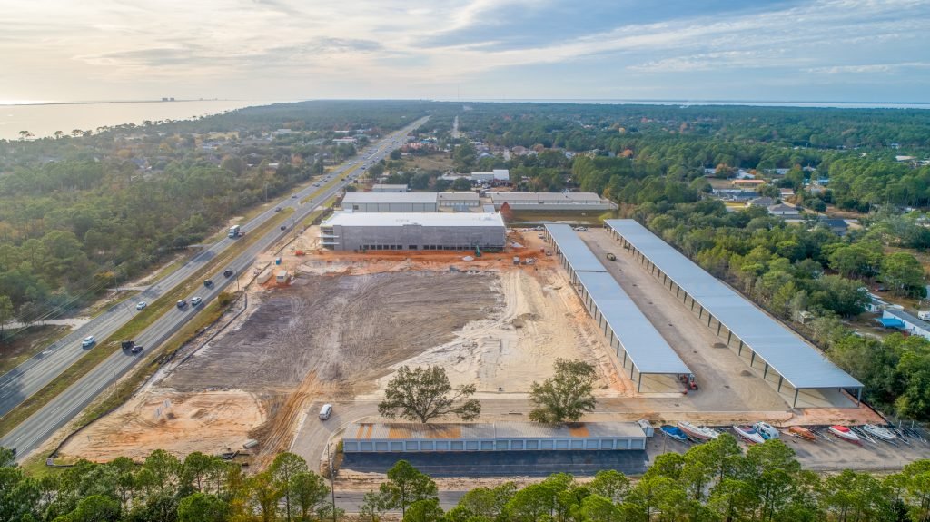
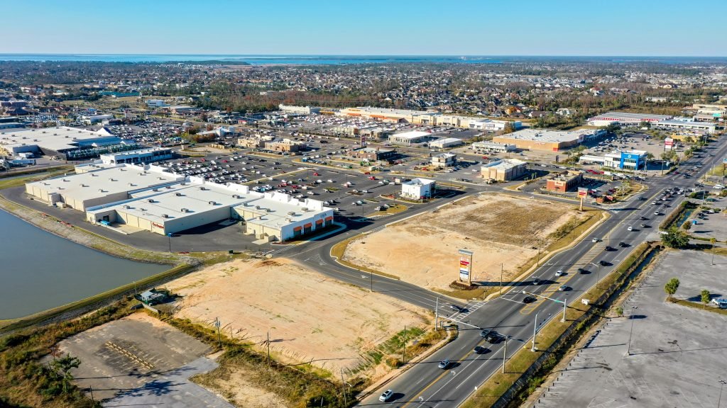
Drone use has revolutionized the way construction companies approach site surveys and mapping. By employing drones equipped with high-resolution cameras, construction professionals can gather accurate topographic data for planning purposes. Traditional surveying methods often require extensive time and resources, but drone surveys offer a more efficient solution.
With drone imagery, construction teams can quickly capture detailed aerial views of construction sites for surveying purposes. This allows them to assess the terrain and identify potential challenges during the initial stages of a project when decisions regarding site layout and design need to be made. By leveraging drone technology, construction companies can save time and money while ensuring that their projects are built on solid foundations through effective surveying.
Site Inspections Made Easy with Drone Technology
Drones have become an indispensable tool for conducting thorough surveying site inspections in the construction industry. These unmanned aerial vehicles enable construction professionals to identify structural issues or defects before they escalate into major problems. By capturing high-resolution images and videos from various angles, drones provide a comprehensive view of the entire site.
Construction workers no longer need to risk their safety by physically accessing hazardous areas or rely solely on ground-level inspections. Drones allow for quick and efficient surveying of rooftops, tall structures, or inaccessible spaces. This not only enhances worker safety but also helps prevent costly delays caused by unforeseen surveying issues.
Progress Monitoring Ensured Through Drone Technology
Surveying is crucial in any construction project. Drones play a vital role in monitoring construction sites to ensure that projects stay on schedule. With regular drone flyovers, project managers can visually document each stage of development accurately.
Construction drone data, obtained through surveying, provides real-time insights into the status of different tasks and allows for prompt decision-making if any deviations from the plan occur. By comparing current images with previous ones, stakeholders can easily identify areas where work may be lagging behind or where adjustments need to be made. This proactive approach to progress monitoring helps construction companies maintain efficiency and meet project deadlines.
Accurate Volumetric Analysis with Drone Technology
Measuring stockpiles and materials on construction sites has traditionally been a time-consuming and labor-intensive process. However, drones have simplified this task through their ability to conduct accurate surveying and volumetric analysis. By capturing high-resolution images of stockpiles from various angles, drones can calculate the volume of materials present without manual intervention.
This technology not only saves considerable time but also improves accuracy by minimizing human error in surveying. Construction companies can now obtain precise measurements of stockpile quantities, ensuring efficient inventory management through surveying. By leveraging drone technology for volumetric analysis in surveying, construction professionals can streamline operations and optimize resource allocation.
Infrared Thermography for Energy Efficiency Detection
Drones equipped with infrared cameras have proven invaluable in surveying construction or renovation processes. Infrared thermography conducted by drones allows for the identification of heat leaks, insulation gaps, or faulty electrical systems that may contribute to energy wastage.
By capturing thermal images of buildings from above using drones, surveying provides a comprehensive overview of potential energy-related issues. This surveying data enables construction teams to rectify problems early on, saving both money and resources in the long run. Incorporating infrared thermography into construction workflows ensures that buildings are constructed or renovated with optimal energy efficiency in mind.
Enhancing Visualization and Design Review Processes
Drones facilitate surveying, 3D modeling, and virtual walkthroughs, significantly enhancing visualization and design review processes in the construction industry. By capturing detailed aerial footage of a site, drones generate accurate 3D models that allow stakeholders to visualize the final outcome before construction begins.
These virtual walkthroughs provide an immersive experience for surveying, helping identify design flaws or potential improvements at an early stage. Construction professionals can collaborate more effectively by sharing drone-generated models with architects, engineers, and clients, enhancing the surveying process. This level of visual representation fosters better communication and ensures that everyone involved has a clear understanding of the project’s vision through surveying.
Partnering with Emerald Coast Drone Pros for Construction Drone Services
Emerald Coast Drone Pros is the go-to company for construction companies looking to harness the power of drones in surveying. With their specialized drone services tailored specifically to the needs of the construction industry, they offer a range of solutions that can revolutionize how projects are executed.
Time is money, especially in the construction industry. That’s why partnering with Emerald Coast Drone Pros for surveying is a smart move. Their experienced teams are well-versed in construction-specific drone operations, ensuring that clients have access to professionals who understand the unique challenges and requirements of the industry.
One of the key advantages of working with Emerald Coast Drone Pros is their ability to provide comprehensive solutions. From aerial photography to advanced surveying, they utilize state-of-the-art drones equipped with cutting-edge technology. This allows construction companies to gather accurate data and gain valuable insights into their projects, ultimately enhancing efficiency and accuracy.
Safety is always a top priority in the construction sector, especially when it comes to surveying. Emerald Coast Drone Pros understands this well and adheres to strict safety standards while delivering high-quality surveying results. By partnering with them, construction companies can have peace of mind knowing that their surveying projects are being carried out in a safe and responsible manner.
Collaborating with Emerald Coast Drone Pros means having reliable support throughout all stages of a construction project, including surveying. Whether it’s capturing initial site data or monitoring progress over time, their team will be there every step of the way. This level of support ensures that clients can maximize the benefits of using drones for surveying without any hassle or technical difficulties.
Let’s take a closer look at some specific surveying services offered by Emerald Coast Drone Pros. They specialize in using construction drones for accurate surveying.
-
Aerial Photography: Using drone images, construction companies can gain a bird’s-eye view of their sites. This helps in planning and visualizing various aspects such as site layout, terrain analysis, and potential obstacles. With access to commercial drone services, companies can collect valuable drone survey data to enhance their understanding of the project.
-
Surveying and Mapping: Drones equipped with advanced sensors and software can quickly and accurately survey construction sites, collecting data for topographic mapping, volume calculations, and 3D modeling. This streamlines the surveying process and provides precise measurements for better decision-making.
-
Inspections: Drones are ideal for inspecting hard-to-reach areas such as roofs, towers, and facades. By using drones instead of manual inspections, companies can save time, reduce risks to personnel, and identify potential issues more efficiently.
-
Progress Monitoring: With regular aerial surveys conducted by drones, construction companies can monitor project progress over time. This allows them to compare actual work done against plans, identify any deviations or delays early on, and take corrective measures as needed.

Unlocking the Potential of Drones in Construction
Drones have revolutionized the construction industry, offering numerous benefits that were previously unimaginable. From cost savings and time efficiency to enhanced safety and risk reduction, drones are transforming the way construction projects are executed. With real-time drone data, project management has become more streamlined and effective. Let’s explore how drones are unlocking the potential in construction.
How Drones are Revolutionizing the Construction Industry
Drones have brought about a paradigm shift in the construction industry by providing innovative solutions to age-old challenges. These unmanned aerial vehicles offer a bird’s-eye view of construction sites, enabling project managers to monitor progress, identify issues, and make informed decisions quickly.
Cost Savings and Time Efficiency with Drone Technology
One of the most significant advantages of using drones in construction is cost savings and time efficiency. Traditional methods require extensive manual labor and time-consuming processes. Drones can perform tasks such as surveying, mapping, and inspections with greater speed and accuracy. This not only reduces labor costs but also minimizes project timelines significantly.
Enhanced Safety and Risk Reduction in Construction Projects
Safety is paramount in any construction project, and drones play a crucial role in enhancing safety measures while reducing risks. By deploying drones for inspections at heights or hazardous areas, human workers can be kept out of harm’s way. Real-time monitoring allows for proactive identification of potential safety hazards before they escalate into accidents.
Improved Project Management with Real-time Drone Data
Real-time construction drone data provides invaluable insights for effective project management. Project managers can access up-to-date information on site progress, material inventory, equipment usage, and more without physically being present at the location. This enables them to make informed decisions promptly, allocate resources efficiently, and ensure smooth coordination among teams using construction drones.
Real-world Use Cases of Drones in Construction
The application possibilities for drones in construction are vast and diverse. They can be used for topographic surveys, 3D mapping, volumetric analysis, thermal imaging inspections, progress documentation, and even structural integrity assessments. These use cases demonstrate the versatility of drones and their ability to tackle various construction challenges.
Partnering with Emerald Coast Drone Pros for Construction Drone Services
To unlock the full potential of drones in your construction projects, consider partnering with Emerald Coast Drone Pros. Our team of experienced professionals specializes in providing comprehensive drone services tailored to the construction industry’s unique needs. From aerial photography and videography to mapping and data analysis, we offer a range of solutions that can revolutionize your construction processes.
In conclusion, drones have emerged as a game-changer in the construction industry. Their ability to save costs, improve efficiency, enhance safety measures, and provide real-time data has made them an indispensable tool for modern-day construction projects. Unlocking the potential of drones opens up new possibilities for more streamlined project management and improved outcomes. Embrace this technology today and experience firsthand how it can transform your construction endeavors.
FAQs
How can drones help reduce costs in construction projects?
Drones can reduce costs in construction projects by streamlining various tasks such as surveying and inspections that would otherwise require extensive manual labor. This not only saves time but also minimizes resource allocation inefficiencies.
Are there any legal restrictions on using drones in construction?
Yes, there are legal restrictions on using drones in construction. It is essential to comply with local regulations regarding drone usage and obtain necessary permits or licenses before deploying them on a construction site.
Can drones improve safety on construction sites?
Absolutely! Drones play a crucial role in improving safety on construction sites by conducting inspections at heights or hazardous areas without exposing human workers to unnecessary risks. Real-time monitoring also allows for proactive identification of potential safety hazards.
What kind of data can be collected using drones in construction?
Drones can collect various types of data in construction, including aerial imagery, topographic maps, 3D models, thermal images, and more. This data provides valuable insights for project management and decision-making processes.
How accurate are the measurements obtained from drone surveys?
Drone surveys can provide highly accurate measurements when conducted by trained professionals using advanced surveying techniques. However, it is important to ensure proper calibration and validation of the collected data to maintain accuracy.
Can drones be used in large-scale construction projects?
Yes, drones can be effectively used in large-scale construction projects. Their ability to cover vast areas quickly and provide real-time data makes them ideal for monitoring progress, identifying issues, and managing resources efficiently.
What are some examples of successful drone applications in construction?
Successful drone applications in construction include site mapping and surveying, progress documentation, structural inspections, material inventory management, and even monitoring worker safety compliance. These applications have proven to enhance efficiency and reduce costs in various construction projects.


